This map of Marquette Park and the north-west section of Miller Beach shows the
former location of 'Chanute Hill' - the large dune just northeast of the Lake Street
Bridge - that Octave Chanute and his assistants used in their first experiments
in the summer of 1896. Since that time the dune has been 'topped' and roads and
houses built on it.
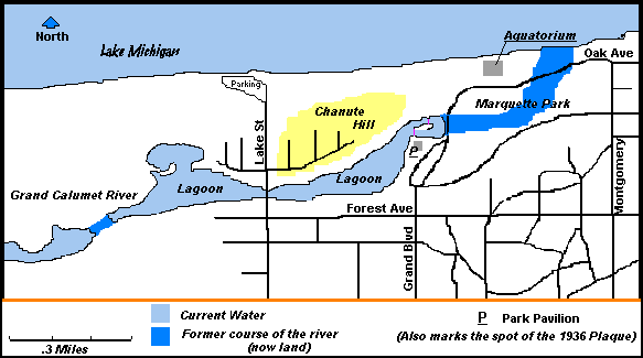
The map also shows the original course of the Grand Calumet River as it existed
in 1896. The mouth of the river leading into the lake was more like marshland and
in the dry season often quicksand. The former mouth of the river is now parking
for the beach. The course of the river was changed in 1908 with the building of
United States Steel Gary Works.Originally, the map on these pages showed the course
of the river going due north from the lagoon. In talking with Fred Carr, who grew
up on the beach in the 1920's, he told me that the river headed further east and
entered the lake east of the Aquatorium.