Affpuddle, Dorset
in the 19th Century

This Being Page Two: The Manor

Page One Being the Parish of Affpuddle.

On this page jump to:
1839 Tithe Map. My family connections. Miscellaneous Resources

While the first page in this two-part series deals with the entire parish of Affpuddle, this page concentrates on what was known as Affpuddle Farm going into the 19th century. It goes into more detail with the 1839 tithe map to demonstrate how the fields, houses, orchards, and gardens were identified and tithe amounts assessed.

The two major farms that emerged from the Manor were West and East Farms which were farmed in the 19th century by ancestors of mine. They were the tenant farmers who paid rent to the owner and hired laborers to work the land, tend sheep and the dairy. The family connections became apparent when I was exploring the genealogy of great grandparents, grand uncles, wives and sons and daughters which I’ve tried to demonstrate graphically.

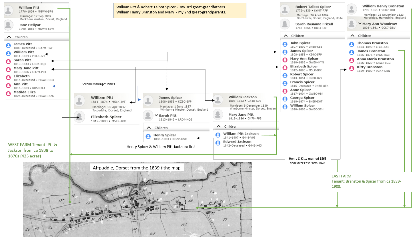
The 1770 Taylor Survey Maps

Until 1675 the Manor of Affpiddle (Footnote: When and why the name changed from Affpiddle to Affpuddle has many theories. The river north of the village is still called the River Piddle, as it was on the 1884 Ordinance Survey map when the town is named Affpuddle. ) had been the domain of the Lawrence family. William Frampton bought it that year for £4,050 and the Frampton family would be owners until 1910. While surveys had been done of the tenements to collect rent from the lease and copyholders, perhaps the surveys, and maps, done in 1770 demonstrate more clearly the extent of the strip fields, houses and gardens. They also give a glimpse of the Manor prior to the enclosures (Footnote: “The word ‘Enclosure’ has different significances. It is used for the extension of arable cultivation over the heaths and wastes and the grubbed-up woodlands, a process which has been going on since the beginning of time…Another use of the word is for the enclosure into bigger fields of the strips in the common arable fields and later the re-deployment into separate farm units. This, which ended the Common Fields, took place in the Affpuddle Manors mainly in the nineteenth century." (Brocklebank, page 39) ) that began in the succeeding decades when one compares them to the tithe maps done in 1839. By then eight farms (Footnote: East and West Farms, Rogers Hill, Briantspuddle, Waddock, Pallington, Brook, and Throop farms. ) were defined and farmed by the tenants who employed agricultural laborers to work the farms. Two of those farms, West Farm and East Farm, were managed William Branston, by 2nd great-grandfather (East Farm), and William Pitt, my 3rd great-grandfather (West Farm). While they were newcomers to the parish in the first decades of the 19th century, many of the laborers they employed were descendants of those who appear as leaseholders in the 1770 survey. And one, William’s wife Mary Ann, née Woodrow, had her roots in those early strip farmers of Affpiddle Manor.

Both East and West Farms stayed within the family throughout the 19th century, by blood or by marriage. My own Spicer family came on to the scene later on, but Henry Spicer senior’s grandfather farmed Waddock farm in the 1820s, was on the vestry of St. Laurence church, and then farmed in Owermoigne, just south of the parish prior to his death in 1839. Moreover, Henry’s wife was the daughter of East Farm’s William and Mary Ann Branston. And Henry’s father, James, had married into the Pitt family of West Farm. Hopefully, these family connections are made clear in the graphic further on in this page.

The following is a closer look at Affpiddle Farm as it looked in 1770. The map is one of seven in the Taylor Survey. A list of the maps in that survey is below.

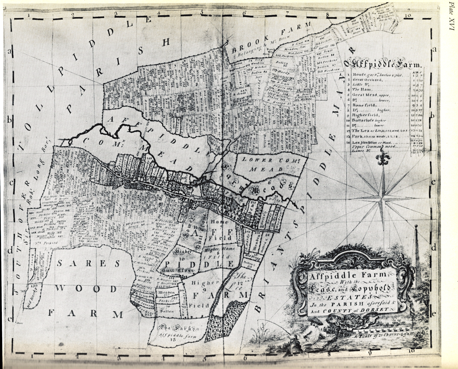
1770 Isaac Taylor Survey of Affpiddle Farm


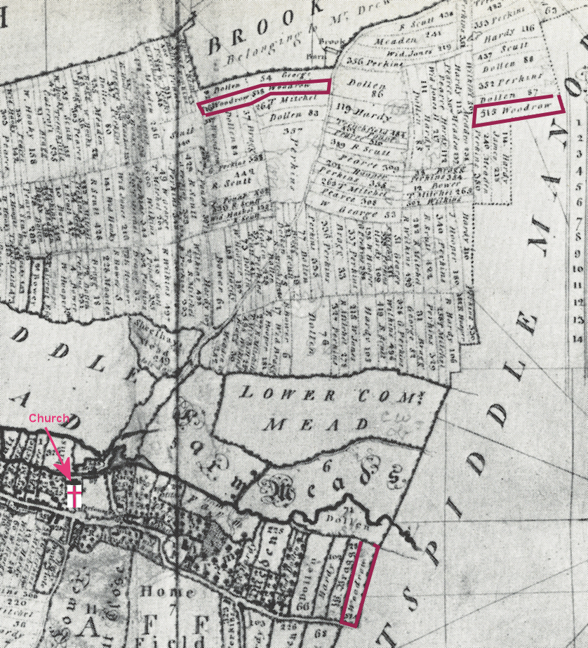
Blow-up of the upper right-center of the Affpiddle Farm map

Summary in the schedule of the Isaac Taylor Survey

Map number of house Leasehold & Copyhold Acres Roods Perches   Total Acres Surname Occurences
on 1841 Census
Affpiddle           [Added data]
1 Bower 18 1 33   18.45
13 Wid Bragg 16 3 37   16.98
29 Bragg 13 3 10   13.81
48 Wm. George 11 13 15   14.34
62 Cowerd 2 1 24   2.394
65 Andrew Dollen 33 3 6   33.786
100,101 Hardy (2 hses) 37 3 31   37.936
130 E. Haskell 4 3 38   4.978
138 Wid Hookey 8 2 7   8.542 21
148 Wm. Hookey 21 1 4   21.274
177 Ld. Hooper 12 1 24   12.394 12
194 W. Hooper 16 3 19   16.864
213 Jones 10 3 26   10.906
225 Js. Meaden 31 2 14   31.584
248 Late Sare 7 0 39   7.234
252 Late Mr. Frampton 0 1 27   0.412
254 T. Mitchell 21 3 29   21.924 9
275 R. Mitchell 15 0 14   15.084
292 Pearce 19 3 10   19.81 12 (or Pearse or Pearcey)
231 G. Perkins 70 1 21   70.376
391 Peter Pount 15 1 10   15.31
412 R. Scutt 58 3 39   58.984 9
471 T. Trenchfield 12 1 13   12.328
494 Rd. Wilkins 15 1 21   15.376
513 Wid. Woodrow 9 1 1   9.256 14
Cottages          
521 John Gould 0 0 25   0.15
522 Diffey 0 0 11   0.066
  Roper 0 0 22   0.132

The blow-up of the 1770 Affpiddle Farm survey map is to illustrate the 9 acres of Widow Woodrow, who would be my 5th great-grandmother Mary Woodrow, née Easter. Her husband John, died in 1767 and she in 1779. She is the 2nd great-grandmother of Kitty Branston. Another surname that occurs is that of Mitchell. While direct connections have not been made yet, Martha Mitchell married the grandson of William Pitt who was William Pitt Jackson, the son of Mary Jane (Pitt) Jackson.

Another name on this survey which jumps out is the second largest copyholder, R. Scutt, whose surname stretches back into the history of the parish, first mentioned in 1525 as one of the wealthy men of the parish. This R. Scutt is likely Robert Scutt (1710-1784) whose 2nd great-granddaughter married, in 1879, James Spicer, my great-grandfather’s first cousin. James and Lucy (Scutt) Spicer were the prosperous farmers of Bovington Farm, just about four miles southeast of Affpuddle.


1839 Tithe maps and Statistics

To open the map in a new tab or window click here.

This portion of the 1839 tithe map corresponds in extent to the 1770 Taylor Map of Affpiddle Manor above.

Curiously, the compass is off as, while the map indicates north up, the Taylor map is more correct: note the angle of the main road.

Below are the field surveys for West Farm and East Farm upon which the tithe was assigned. You can switch between the two farms.

West Farm of William Pitt, Occupier. As of December 13, 1838.
423 acres, two roods, 23 perches. A tithe of £10 2s.
West Farm Name Cultivation Acres Roods Perches
Number: 8 Mead Meadow 1   47
Number: 9 Orchard Orchard   3  
Number: 10 Garden Garden     17
Number: 11 Dairy House, Yard, etc Homestead   1  
Number: 14 Higher Cowleaze, and Meadow 9 2 37
Number: 14a Meadows Close        
Number: 15 Hookey's Field Meadow 1 3 1
Number: 15a          
Number: 19 House, etc       2
Number: 20 Fuel House       2
Number: 27 House and garden Garden   1 20
Number: 29 House and garden Garden   1 20
Number: 30 House and garden Garden   1 20
Number: 31 House and garden Garden   1 23
Number: 41 South Common Field Arable 76 1 9
Number: 34 Garden Garden     20
Number: 42 Baycerne Arable 3 2 3
Number: 37 House and garden Garden     22
Number: 39 House, Garden, Yard, etc     1 39
Number: 46 Coppice Field Pasture 5 2 14
Number: 43 Lute Perkins Baycerne Arable 1 3 13
Number: 44          
Number: 47 Sares Wood-Barn & Yard Homestead   2 5
Number: 48 East Arnolds' and Pasture 15 1 24
Number: 51 Newfield Pasture 10 3 37
Number: 52 West Arnolds' Arable 11 3 15
Number: 53 Downshill Arable 11 3 15
Number: 54 The Portion Field Arable 17 3 26
Number: 55 Middle Field Arable 14 2 27
Number: 56 Barn Field Arable 15 2 31
Number: 57 Lower Great Field Arable 13 1 30
Number: 58 Upper Great Field Arable 17 3 11
Number: 59 The Western Part of South Arable 38   5
Number: 60 South Cowleaze Pasture 13 2 9
Number: 61 South Cowleaze Arable 4    
Number: 62 Mead Gate Ground Arable 2 1 35
Number: 63 Field West of Prands' Pasture 3   9
Number: 64 Pounts' Paddock Pasture 2   25
Number: 66 The Upper Meadow Water Meadow 57 2 10
Number: 67          
Number: 67a          
Number: 68 Yonder North Field Arable 31 3 18
Number: 69 The Upper North Field Arable 31 3 18
Number: 70 The Lower Part of North Pasture 10 1 10
Number: 71 Field        
Number: 72 The North Barn & Yards Homestead   1  
Number: 85a House and garden Garden     20
Number: 104 Braggs' Orchard Orchard 1 1  
Number: 105 Barn, Yard and cottage Homestead   2 4
Number: 106 Chapels' Close Meadow 1 1

My family connections to the parish.

The following graphic I drew to illustrate the major connections of my family to the farms of Affpuddle. Some children have been omitted to save space and confusion. There are other connections that were made by marriage. For instance, William Pitt Jackson, who was Henry Spicer's first cousin, married Martha Mitchell, whose brother George farmed Briantspuddle East and later Rogers Hill.

Robert Spicer, Henry's grandfather, farmed Pallington and Waddock in the first decades of the century before taking on the farm at Owermoigne just south of the parish.


Miscellaneous: List of 1770 maps and Rentals of East and West Farms

The following is a list of the 1770 Taylor survey maps as reproduced in Joan Brocklebank's Affpuddle.

Plate XVI: Affpuddle Manor (Affpuddle Farm map above)
Plate XVII: Bryantspuddle and Throop Manors
Plate XVIII: Sares Wood and Sares Wood Farm
Plate XIX: Oakers Wood and Affpuddle Heath Enclosures
Plate XX: Ashley Farm and Rogers Hill Farm
Plate XXI: Waddock Farm
Plate XXII: Pallington

Rentals in the late 19th century

Rental 1864
Affpuddle East Mr. Jas. Branston £ 582. 10. 0
Affpuddle West Mr. William Jackson £ 575
Rental 1871
Affpuddle East Mr. Jas. Branston £ 582. 10. 0
Affpuddle West Mr. William Jackson £ 595
Rental 1886
Affpuddle East & Bryantspuddle West Mr. Henry Spicer £ 700
Affpuddle West Mr. William Jackson £ 500 *
For rentals for the whole parish see the table on the parish page.

Links and Other Resources

1.) Dorset Online Parish Clerks (OPC) is an awesome and invaluable site for anyone interested in the parish. Click for the Affpuddle Page.
2.) "A Vision of Britain Through Time" has a number of pages on all things Affpuddle. The following open in a new window/tab.
  1. Main Portal.
  2. Total Population through Time.
  3. Portal to Statistics.
  4. Area.
There is also a portal for Turners Puddle
3.) An interesting history of Briantspuddle at the Briantspuddle Community Website.

Other Resources:

  1. 'Affpuddle', in An Inventory of the Historical Monuments in Dorset at British History Online.
    ---While 50 years old, this is an interesting inventory of structures throughout the parish, although strangely the mills are absent.
  2. Brocklebank, Joan, Affpuddle in the county of Dorset A.D. 987-1953. (1968, Bournemouth: Horace G. Commin Ltd., 124 pages with illustrations and maps).
    --- An invaluable source of information on the parish. My father must have met her in 1977 as I have an inscribed copy.
  3. The National Library of Scotland Map Archive is an amazing resource for exploring England and Scotland.
    --- I always find something new on those maps that I didn't know before. https://maps.nls.uk/ (New window or tab.)

Footnotes

Footnotes:


Page created October, 2020

© Text copyright: Steve Spicer

Feel free contact me about this page.